気象業務支援センター |
平成29年度の業務目的
地球温暖化には疑う余地がないとする気候変動に関する政府間パネル(IPCC)第5次評価報告書を受け、平成27年11月には「気候変動の影響への適応計画」が閣議決定された。以後、各省庁で適応計画の立案・検討が始まった。また、同年12月には、気候変動に関する国際的枠組みであるパリ協定が世界的合意の元で採択されている。こうした状況において、気候予測計算出力は、将来の気候状態を斟酌するために使用されるばかりでなく、適応研究の利用に耐えうる精度や品質が求められるようになってきている。また、地域社会に多大な影響を与える極端事象の将来変化について、それぞれの地域の気候特性を考慮に入れた科学的に根拠のある説明が求められる。これら多様な社会的要請に応えていくためには、本研究グループがこれまでに行ってきた全球と領域スケールの力学的気候計算を一層高精度なものとし、実用に耐えうる研究プロダクトを提供していくことに加え、その活用に向けた論文・一般ユーザーに向けた解説等が必要である。
これまでの高解像度大気モデルを活用した地球温暖化予測計算では、基本気候要素である地上気温と降水量に関わる極端現象と台風の将来変化を評価することに成功した。一方で、「持続可能な開発目標(SDGs)」に謳われるように、気候変動に対する社会、経済、環境等での持続可能な具体的対策が検討されるようになる今後の局面においては、環境因子となる気温・降水量に加えて他の物理的な諸量についても精度の高い情報が求められる。また、人間活動に起因する種々の影響を全球的に評価できるように、化学的気候情報の作成も新たな視野にいれておく必要がある。
このような今後の多様な社会的要請に対応していくために、本研究課題では以下の目標をたてて研究を進める。
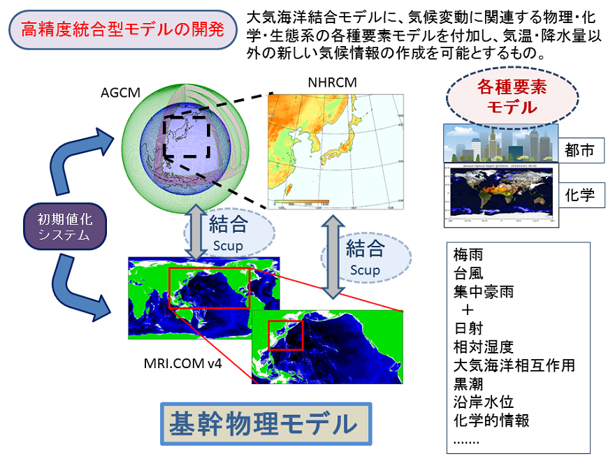
「高精度統合型モデルの開発」では、創生プロまでは大気モデルを用いた気候計算が中心であったが、気象・気候の様々な事象に対する海洋の影響を考慮し、大気海洋相互作用を評価できる高解像度大気・海洋結合系ベースの気候モデルへ移行する。また、新たなモデルコンポーネントを導入し物理変数の精度を向上させ、環境評価に必要な化学的気候情報が作成可能となるモデルの統合化に取り組む。また、本業務においては、将来予測実験のみならず、過去の温暖化を気候学的に検証するために、過去の大気海洋観測データと、創生プロで開発したアンサンブルデータ同化システムを発展させて、150年気候再解析を試みる。
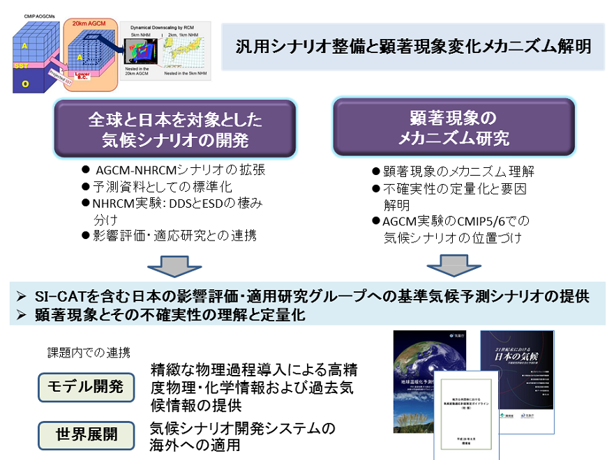
「汎用シナリオ整備とメカニズム解明」では、水資源・農業・健康など、多岐にわたる影響評価やリスク管理での利用に耐えうる温暖化気候データセットを「汎用シナリオ」として整備するとともに、それらデータを用いた顕著現象や極端現象の将来変化メカニズムの研究を高解像度の全球・領域大気モデルの特徴を生かして実施し、気候シナリオの信頼性を高め、かつメカニズム研究に資するデータセットの構築を目指す。また台風の将来変化に特化した領域大気海洋結合モデル及び雲解像モデルによる実験を実施し、メカニズムに着目しながら顕著現象将来変化の不確実性の評価に取り組む。
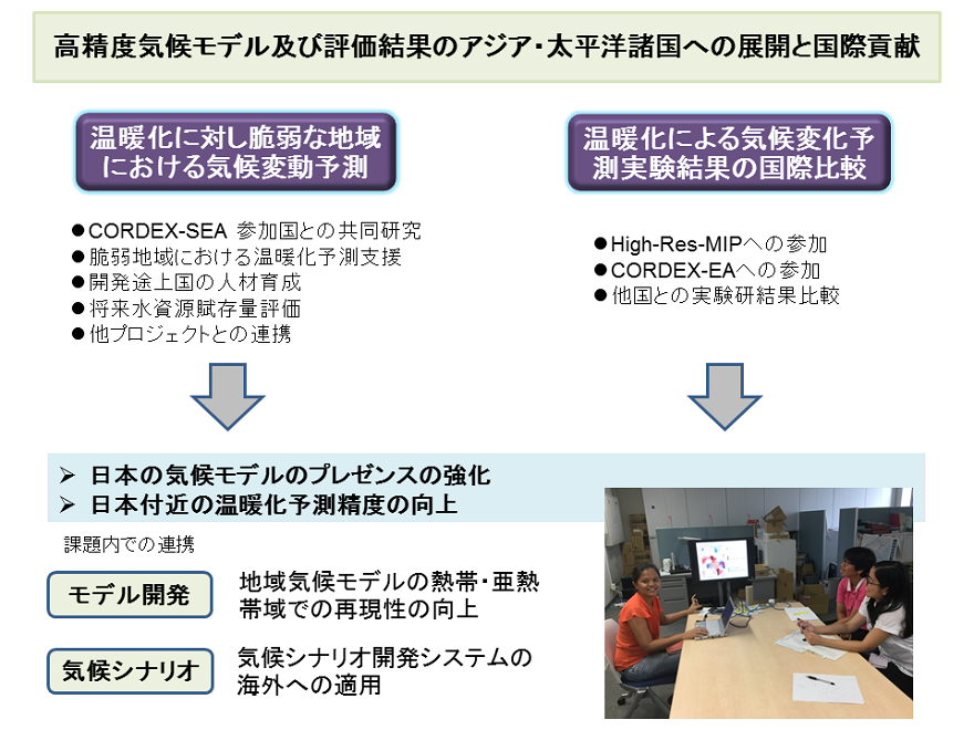
「高精度気候モデル及び評価結果のアジア・太平洋諸国への展開と国際貢献」では、東南アジア・中米などを対象として、気象研究所が開発したダウンスケーリングモデルを国際的にも普及させる取り組みを行う。本領域課題においては領域テーマC、D連携の枠組みを利用して現地の影響評価研究に活用してもらう仕組みの実現も試みる。
本課題の社会へのアウトリーチは、国内的には、当プログラムの領域テーマD「統合的ハザード予測」、SI-CATプログラム等との連携、また気象庁「地球温暖化予測情報」、環境省「気候変動適応情報プラットフォーム」等を活用し社会への情報提供を試み、また、国際的にはIPCCへの寄与、CMIPやCORDEX-Asiaなどの国際共同研究への参加により取り組む。東南アジア諸国・中米等との連携が、地域気候モデルを介した現地気候研究者の養成という形で結実し、またここでの計算・解析結果が各国の「地球温暖化予測情報」に反映するされるなど、アジア地域における、我が国発の気候モデルのデファクト・スタンダード化を目指す。
以上の目的のため、本事業では以下の研究課題を実施する。
領域課題(i)「高精度統合型モデルの開発」
領域課題(ii)「汎用シナリオ整備とメカニズム解明」
サブ課題a「汎用シナリオ整備と顕著現象変化メカニズム解明」
サブ課題b「台風等極端事象の高解像度ダウンスケーリングシミュレーション」
領域課題(iii)「高精度気候モデル及び評価結果のアジア・太平洋諸国への展開と国際貢献」

平成29年度の成果目標及び業務方法
領域課題(i)「高精度統合型モデルの開発」
(目標)
温暖化研究及び影響評価・適応研究に有用な中長期気候予測プロダクトの生成が可能となる高解像度大気海洋結合モデルの開発を開始する。
(業務の方法)
気象研究所がこれまでに開発してきた既存の大気、海洋、陸面、化学輸送モデル、そして領域モデルの更新のために、新しく導入を計画する都市モデルなどのコンポーネントを含めたモデルデザインの細部を検討した上で、開発作業の優先順位づけを行い、モデル開発・研究に着手する。さらに、領域課題「高精度気候モデル及び評価結果のアジア・太平洋諸国への展開と国際貢献」で対象とする低緯度域での領域モデルの再現性の向上も視野に入れる。これらに加え、150年気候再解析のためのアンサンブルカルマンフィルタに基づくデータ同化システムについては、その高解像度モデルへの組み込みを行い、過去台風の再現も可能となるように、既存の同化スキームの高度化に着手する。

領域課題(ii)「汎用シナリオ整備とメカニズム解明」
(目標)
アジア・日本域における予測不確実性を評価するために、異なる初期値や異なる海面水温パターンを用いたアンサンブル実験を開始する。
(業務の方法)
これまでに開発してきた大気全球―領域気候温暖化予測システムを用いて、自然変動による不確実性を定量化するための、全球20km、日本域5kmと2kmでの、現在気候初期値アンサンブル実験を開始する。また、全球60km、日本域20kmでの、100年以上連続の温暖化再現・予測シミュレーションを開始する。これらの実験開始に当たっては、領域テーマDと緊密な連携をとりながら、実験設定等を調整する。全球60km大気モデルを用いて、将来海面水温パターンの違いがアジア・日本域における顕著現象の予測不確実性に及ぼす影響を調査する。また、創生プロで実施した5km・2km領域モデルの現在気候実験における極端現象の気候値再現性について解析を行う。さらに、創生プロで整備した温暖化予測データセットの、CMIP5モデルアンサンブル内での位置付けについて、顕著現象変化を中心に解析を開始する。
(目標) (業務の方法) (目標) (業務の方法)
業務の遂行に当たっては、研究連絡会を開き各課題間の連携を確認し、研究運営委員会により外部有識者等からの全体の研究課題に対する意見や示唆を得て
研究の方向付けについて確認します。統合領域テーマDとの連携を図るためC/D連携研究会を領域テーマDと共催・参加し、また国内外の関連会合に参加して情報交換を行います。
研究のアウトリーチとしては、著しい論文の成果については報道発表を行い、一般向けの講演会等での機会を得て研究成果を公開します。
本課題成果の温暖化研究への有効活用を目指し、国内外の各種温暖化適応研究プロジェクトとの連携を図ります。
アジア脆弱域をはじめとする世界との今後の連携を目指し、また情報交換を効率的に進めるために国際ワークショップを主催することを検討します。
今年度計算されるデータの蓄積と解析のためにサーバ・ストレージシステムを整備します。
気象研究所がこれまでに開発してきた既存の大気、海洋、陸面、化学輸送モデル、そして領域モデルの更新のために、新しく導入を計画する都市モデルなどのコンポーネントを含めたモデルデザインの細部を検討した結果、気象研究所地球システムモデルをベースに全球大気海洋結合モデルにより温暖化予測情報を出すためのモデル開発・研究に着手した。ここでは、領域課題(ⅲ)「高精度気候モデル及び評価結果のアジア・太平洋諸国への展開と国際貢献」で対象とする低緯度域での領域モデルの再現性の向上も視野に入れて作業を行った。また、領域モデルに海洋を結合させて、結合系を含めた日本域の気候特性メカニズム研究を行うためのシステム開発を開始し、本年度は、海洋の解像度の違いによる領域再現の相違について考察した。150年気候再解析のためのアンサンブルカルマンフィルタに基づくデータ同化システムについては、その高解像度モデルへの組み込みを行い、過去台風の再現も可能となるように、既存の同化スキームの高度化に着手した。 サブ課題(a)「汎用シナリオ整備と顕著現象変化メカニズム解明」 これまでに開発してきた大気全球-領域気候温暖化予測システムを用いて、自然変動による不確実性を定量化するための、全球20km、日本域5kmと2kmでの、現在気候初期値アンサンブル実験1例を開始した。本実験は完了し、これまでの実験と合わせて解析を進めている。極端降水量の変化については、Clausius-Clapeyron式による大気中の飽和水蒸気量の増加に加えて、中立浮力高度に関係することが示唆された。加えて、同システムによるRCP2.6の下での今世紀末の全球20km、日本域5kmと2kmでの実験を開始した。また、全球60km、日本域20kmでの100年以上連続の温暖化再現・予測シミュレーションを開始した。これらの実験開始に当たっては、領域テーマDと緊密な連携をとりながら、実験設定等を調整した。全球60km大気モデルを用いて、将来海面水温パターンの違いがアジア・日本域における顕著現象の予測不確実性に及ぼす影響を調査し、熱帯北西太平洋降水量は、MRI-AGCM3.2はCMIP5大気モデルと比べて、amip4K応答の降水増加量が小さく、amip4xCO2応答の降水減少量が大きく、MRI-AGCM3.2とCMIP5大気モデルはともに、amipPattern応答は降水減少を示すことを明らかにした。また、創生プロで実施した5km・2km領域モデルの現在気候実験における極端現象の気候値再現性について解析を行った。極端降水の再現性は、5kmよりも2km領域モデルの方が良い結果が得られた。北海道北西部における極端な降水量の増加メカニズムについて要因分析を行い、西風強化が主要因であることを明らかにした。さらに、創生プロで整備した温暖化予測データセットの、CMIP5モデルアンサンブル内での位置付けについて、顕著現象変化を中心に解析を開始した。最初に行った季節平均気候値の比較では、MRI-AGCM3.2S/Hの再現性がCMIP5マルチモデルアンサンブル平均と同等であるという結果が得られた。 サブ課題(b)「台風等極端事象の高解像度ダウンスケーリングシミュレーション」 領域大気海洋結合モデル及び雲解像モデルを用いた台風の再現実験と全球モデル実験の台風のダウンスケーリングシミュレーションを実施するために、まず、これまで創生プロで開発してきた非静力学大気海洋結合モデルの海面交換過程の改良を行い、台風のより精度の高い強度予測が可能な結合モデルのシステムの構築を行った。さらに、これを用いて観測された特に強い台風についての再現実験を行い、その再現性を検証するとともに、最大強度に達するプロセスとメカニズムを調べた。台風MEGI(2010)では、内部コアの海面水温分布により発達の程度が決まることを示した。これと平行し、大気だけのモデル(雲解像モデル)によるシミュレーションを行い、海洋結合のインパクトを示した。内部コアの海面水温分布を結合モデルではじめて再現できることを示した。また、全球モデルの台風の力学的ダウンスケーリング実験を開始した。d4PDFを用いてダウンスケーリング実験を行えるようにし、特に北海道に上陸する台風を選定して、実験を開始した。 創生プロで計算した大気モデル(AGCM)の計算結果を用い、東南アジア域の脆弱地であるメコン川流域・ベトナム中部を含む領域で、5km以下の分解能のNHRCMによる現在気候再現実験及び将来予測実験を行った。この実験は、統合地域ダウンスケーリング計画(CORDEX)-SEAの参加国であるタイ、ベトナムから招聘した研究者に領域気候モデルNHRCMの使い方の指導をしながら行った。また、領域テーマDと緊密な連携をとりながら、計算領域や出力要素等の実験設定等を調整した。本課題で行った実験は、①タイ全土における5km分解能の現在及び将来予測実験、②メコン川流域と③ナン川・ヨム川流域における2km分解能の現在及び将来予測実験、④ベトナム全土及び⑤インドネシアのバタンハリ川流域における5km分解能の現在気候再現実験である。その結果、①タイでは降水量を北部では過小評価していたが、南部では再現性が良かった。②メコン川流域では、降水量は過小評価の傾向があるが、季節変化はおおむね良好にとらえていた。③ナン川・ヨム川流域は、境界条件の影響を受けて降水量が過小評価の傾向にあるが、水平分布は良好であった。④ベトナムでは850hPa面の風の場は、ERA-Interim再解析と比べて非常に高い再現性を示していた。また、降水量の季節変化も非常によく再現されていた。⑤バタンハリ川流域の降水量の水平分布は、おおむね良好に再現されていたが、山岳部でやや過大評価の傾向があった。さらに、これまでに創生プロで行ってきたパナマにおけるダウンスケーリング実験の結果を解析し、モデルの現在気候再現精度評価に着手した。これには、対流のパラメタリゼーションを変えた2種類の実験が行われた。Grellスキームを使うと降水量の領域平均値は観測とほぼ同じであったが、空間相関が良くなかった。一方、Kain-Fritschスキームを使うと空間相関は良いが、全体的に過大評価となった。HighResMIPに参加するため20km解像度のAGCMを用いた現在気候再現実験を開始した。CORDEX-EAに参加するために、創生プロで計算した60km解像度のAGCMの現在気候再現実験の結果を、NHRCMを用いてダウンスケーリングを行った。その結果、冬季降水量は,東アジアの大部分で他の地域に比べ少ないという特徴をよく再現していた。また、日本の日本海側で冬季季節風に伴う降水の再現性も良好であった。一方、夏季降水量に関しては、東南アジアの山沿いやヒマラヤ山脈で降水量の過大評価が顕著であった。逆に、ベトナムの平野部では降水量を過小評価していた。 業務の遂行にあたって、定期的に研究連絡会を開き各課題間の連携を確認した他、研究運営委員会において外部有識者等からの全体の研究課題に対する意見や示唆を得て研究の方向付けを確認した。統合領域テーマDとの連携を図るためC/D連携研究会を開催した。また国内外の関連会合に参加・発表して情報交換を行った。研究のアウトリーチとして著しい論文の成果について報道発表を1件行った他、一般向けの講演会等での機会を得て研究成果を公開した。本課題成果の温暖化研究への有効活用を目指して、SI-CATをはじめとする国内外の温暖化適応研究プロジェクトとの連携を図った。さらにアジア脆弱域をはじめとする世界との今後の連携および情報交換を目的として国際ワークショップを主催した。今年度計算したデータの蓄積と解析のためにサーバ・ストレージシステムを整備した。 Japan Meteorological Business Support Center: Izuru Takayabu As a successor of "Program for Risk Information on Climate Change (SOUSEI)" carried out for 5 years (FY2012-2016), the Ministry of Education, Culture, Sports, Science and Technology (MEXT) has established an advanced program for 5 years (FY2017-2021), "Integrated Research Program for Advancing Climate Models (TOUGOU)" with 4 themes from A to D: This program aims to further develop climate models and to reflect the knowledge gained through them in the adaptation plans of actual regions to the questions that society needs answers for in this process will open the door to a new type of science.
Using the world-class supercomputers, such as Earth Simulator, we are pursuing research and development in which all themes are organically linked. Our research and development include prediction and diagnosis of imminent global climate change expected to occur within a few years or decades, research on greenhouse gas emission scenarios and associated long-term climate change projections, development of probabilistic climate change projection techniques, and development of technology for precise impact assessment, etc. International society is seeking stronger cooperation with "the physical science basis" of Working Group I (WGI) and "impacts, adaptation and vulnerability" of Working Group II (WGII) within the Intergovernmental Panel on Climate Change (IPCC). In Japan, the development of global warming adaptation measures for all the local government units and various types of information on warming projections for use in those measures are being sought. Among warming projections, the change in the probability of extreme weather, for example typhoons and heavy rainfall during the rainy season, has recently drawn a lot of attention. High-resolution and precise global and regional climate models will be used in this theme and with the aim of elucidating how and why extreme weather changes that can have such a major impact on regional climates occur. The data from warming projection calculations can then be used it examine the types of impact they will have on society. Data that meets all of the types of demand for it therefore needs to be output. In area Theme C, we intend to carry out future projections and experiments for use in reproducing current climates in various scenarios and experiments that reproduce past climates through assimilating data. Then, by assessing the adequacy of the resulting data, we can provide the various users of it with guidelines for them to use in making the decision on which data they can best use. In addition, we intend to develop a new and high-resolution downscaling model system to ensure that the data can then be utilized in a greater variety of fields, in warming impact assessment of environmental contamination, and in agriculture and renewable energy etc. The studies will be used in coordinated studies that include staff exchanges with other countries that are vulnerable to global warming (e.g. Southeast Asian countries) as well as in domestic coordinated studies. In this way, the studies can then contribute to warming projections for use at actual sites and studies on their utilization. Japan Meteorological Business Support Center: Masayoshi Ishii For further improvement of future-projection products used for climate change adaptation and mitigation, we are developing global and regional coupled models of high resolution, which is a revision of the present earth system model of the Meteorological Research Institute of the Japan Meteorological Agency. So far, we conducted time-slice experiments with high-resolution atmospheric models for future changes in extreme weather and climate events such as typhoon and strong precipitation. The versions of the same model have been used under consecutive domestic global-warming research programs called KYOSEI, KAKUSHIN, and SOUSEI. The model performances are still the best among atmospheric modes used for global warming studies world-wide. However, the models ignore air-sea coupling and they produce atmospheric states only. That is why we introduce coupled models for conducting future projections with time-slice experiments. Such coupled experiments provide us more physically consistent products than ever and these should be informative in relation to understand future climate changes in extreme events as well as mean states. We also plan to examine the possibility of atmospheric chemistry products by introducing chemistry models including complicated chemical processes and transportation. These physical and chemical products will hopefully respond to various social demands. a: Development of climate scenarios for multi-stakeholder applications and understanding the mechanisms of future changes in extreme events Japan Meteorological Business Support Center: Toshiyuki Nakaegawa We performed a present-day climate simulation with future climate projection system using global and regional climate models with 20, 5 and 2 km horizontal resolutions to quantify the natural variabilities in atmosphere and are performing a future climate simulation at the late 21st century under the RCP2.6 scenario. We are also performing a seamless long-term simulation for more than 100 years with 60 and 20 km versions of the global and regional climate models, respectively. The experimental designs were determined after discussion with the Theme C and D members. b: High-resolution simulation of typhoons and extreme events Nagoya University: Kazuhisa Tsuboki Most extreme phenomena are caused by typhoons: heavy rainfall, violent winds and storm surges. The purposes of the present study are to clarify the mechanisms of extreme phenomena associated with typhoons using a high-resolution model and their future changes in association with the climate change using pseudo-global warming (PGW) experiments and dynamic downscaling experiments. In this year, we performed simulations of the most intense typhoon in the 21st century and examined the process and mechanism of the development. The impact of ocean coupling was also shown. A dynamic downscaling experiment of future typhoons was begun using a cloud-resolving model. Japan Meteorological Business Support Center: Hidetaka Sasaki 1) Climate change projections in vulnerable areas 2) Intercomparison of climate change projections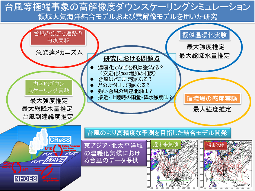
領域大気海洋結合モデル及び雲解像モデルを用いた台風の再現実験と全球モデル実験の台風のダウンスケーリングシミュレーションを実施する。
領域大気海洋結合モデル及び雲解像モデルを用いた台風の再現実験と全球モデル実験の台風のダウンスケーリングシミュレーションを実施するために、まず、これまで創生プロで開発してきた非静力学大気海洋結合モデルの海面交換過程の改良を行い、台風のより精度の高い強度予測が可能な結合モデルのシステムの構築を行う。さらに、これを用いて観測された特に強い台風についての再現実験を行い、その再現性を検証するとともに、最大強度に達するプロセスとメカニズムを調べる。これと平行し、大気だけのモデル(雲解像モデル)によるシミュレーションを行い、海洋結合のインパクトを示す。また、全球モデルの台風の力学的ダウンスケーリング実験を開始する。
東南アジアの脆弱地域を対象にした温暖化予測実験を開始する。
創生プロで計算した大気モデル(AGCM)の計算結果を用い、東南アジア域における脆弱地域一か所で、5km以下の分解能のNHRCMによる現在気候再現実験及び将来予測実験を行う。この実験は、統合地域ダウンスケーリング計画の東アジア版であるCORDEX-SEAの参加国から招聘を行い、その招聘研究者に領域気候モデルNHRCMの使い方の指導をしながら行っていく。また、領域テーマDと緊密な連携をとりながら、実験設定等を調整する。さらに、これまでに創生プロで行って来たパナマにおけるダウンスケーリング実験の結果を解析し、モデルの現在気候再現精度評価に着手する。HighResMIPに参加するため20km解像度のAGCMを用いた現在気候再現実験を開始する。CORDEX-EAに参加するために、創生プロで計算した60km解像度のAGCMの現在気候再現実験の結果を、NHRCMを用いてダウンスケーリングを行う。
領域課題(i)「高精度統合型モデルの開発」
領域課題(ii)「汎用シナリオ整備とメカニズム解明」
領域課題(ⅲ)「高精度気候モデル及び評価結果のアジア・太平洋諸国への展開と国際貢献」
Area Theme C: Integrated Climate Change Projection
Theme A: Prediction and Projection of Large-Scale Climate Changes Based on Advanced Model Development;
Theme B: Sophisticated Earth System Model for Evaluating Emission Reductions Needed;
Theme C: Integrated Climate Change Projection; and
Theme D: Integrated Hazard Projection.
Sub-theme (i): Development of high-precision models integrated with climate-relevant processes
Needless to say, understanding past climates for more than 100 years is as important as predicting future climates in the next 100 years. At present, the past climates are limitedly known particularly before the International Geophysical Year (1957-1958). Even in the past climate, strong typhoons landed on Japan islands, and the old Japan experienced severe disasters due to heavy rain and drought. It is beneficial to modeling and climate predictions to understand how and why these events occurred in long-term climate fluctuations. Therefore, a study for 150-year climate reanalysis is incorporated in this sub-theme. Here, we will develop a system of long-term data assimilation with sparse observations.
Sub-theme (ii): Development of climate scenarios for multi-stakeholder applications and understanding the mechanisms of climate change
We examined the effects of spatial pattern of future sea surface temperatures on changes in severe meteorological phenomena and their uncertainties. Extreme precipitation is influenced by the level of neutral buoyancy as well as well-known increase in precipitable water based on the Clausius-Clapeyron relationship. Large ensemble simulations of the Database for Policy Decision-making for Future Climate Change (d4PDF) allow us to reveal the robust future changes in occurrences, existence, and severe intensity of tropical cyclones under a +4, world with statistical significance. The occurrence of tropical cyclones in the future climate is projected to globally decrease by 33%. We started analyzing the characteristics of mean states and climate extremes in our future climate projections with MRI-AGCM3.2S/H among the CMIP5 model ensemble. The mean states of the present-day climate simulation of MRI-AGCM3.2S/H are as well reproduced as those of CMIP5 multi-model ensemble mean.
Analyses on the NHRCMs show that extreme precipitation in the 2-km present-day climate simulation reproduces better compared to the 5-km one. Future changes in extreme precipitation in northwestern part of Hokkaido Island is due to the enhanced westerly wind in the future climate rather than to the increase in precipitable water. Cloud-resolving present-day climate simulation with 2-km resolution and simulation with 5-km convection-scheme shows different relationship between elevations and annual maximum snow depth. We also performed additional and extension simulations of d4PDF and found that the interannual variabilities in annual number of days with greater than 100 mm/day are correlated with the interannual variabilities in sea surface temperatures and induced large-scale circulations in some areas but not so in others.
Typhoon Megi (2010) is the most intense typhoon in the 21st century. It attained the minimum sea level pressure of 885 hPa after the rapid intensification. The high-resolution simulation experiment showed that the storm developed rapidly when the sea surface temperature (SST) has a peak at the storm center while the development of the storm stops when the SST at the center is lower than that of the surrounding area. The result indicates that a detailed SST distribution is necessary for accurate prediction of development of a very intense typhoon.
The future change of typhoon-related heavy rainfall is another important research topic. A record-breaking rainfall amount was brought by four typhoons which made landfall in the northern Japan in August 2016. The future change of such extreme events is a big issue for typhoon disaster prevention. To answer this problem, we performed PGW experiments of one of the four typhoons. The result of the PGW experiments showed that the northward movement speed was slower and the minimum central pressure was lower in the PGW experiments than the simulation experiment. The rainfall distribution was more localized and was more intense. The rainfall in the region far distance from the typhoon becomes more intense owing to the large moisture flux to the northeast of the typhoon center.
A dynamic downscaling experiment was started using CReSS and d4PDF data to examine the future change of typhoons approaching the northern Japan. We expect to obtain high-resolution data of typhoons and associated heavy rainfalls by further experiments of the d4PDF typhoons.
Sub-theme (iii): Advancing international collaboration through the application of a high-performing climate model over many countries in the Asia-Pacific region
Six researchers were invited to the Meteorological Research Institute (MRI) in order to conduct collaborative researches on climate change projection around their homelands in FY2017. Invited researcher from Thailand carried out some sensitivity tests of NHRCM over Thailand as reproducibility of NHRCM varies by region. According to the results, climate change projection over whole Thailand was executed by using 5-km grid spacing NHRCM (NHRCM05). Two climate change scenarios whose horizontal grid space was 2-km were made over Mekong river basin and Nan and Yom river basin by using the calculated result of NHRCM05 for the boundary conditions of them. Invitee from Vietnam simulated the present climate by using NHRCM05 over whole Vietnam region. The reproducibility of wind and precipitation is good in Vietnam. Philippines researcher carried out only sensitivity tests to precipitation in this fiscal year. No researcher was invited from Indonesia in this fiscal year, however, the present climate simulation was conducted by using NHRCM05 for the reason that Theme D requested the climate change scenario around Batang Hari River basin. Two convective parameterization schemes were validated in Panama. Precipitation bias was small, but space correlation was low in Grell scheme. On the other hand, in Kain-Fritsch scheme, precipitation was largely overestimated, but space correlation was high as compared with in Grell scheme.
The simulation of the present climate has been started by using 20-km grid spacing AGCM in order to participate in the HighResMIP, which is an international project to compare the results of high resolution global models. Downscaling experiments from ERA-Interim reanalysis and AGCM were conducted by using 20-km grid spacing NHRCM over the East Asian region in order to participate in CORDEX-EA. The characteristic that the precipitation in eastern part of Asia is little as compared to the other region in winter was well reproduced in NHRCM. The precipitation due to modification of air mass over the Japan Sea was also well reproduced on the Japan Sea coast in winter. On the other hand, the precipitation was overestimated around the Himalayas and underestimated over the plain area in Vietnam in summer.