気象業務支援センター |
平成30年度の業務目的
地球温暖化研究をめぐる情勢としては、国際的には気候変動に関する政府間パネル(IPCC)第6次評価報告書が2021年刊行に向けて準備が始まっている。この中では、第1作業部会(温暖化予測の科学的知見)と第2作業部会(温暖化への適応策)、第3作業部会(温暖化緩和策)間の連携がより一層求められている。また、気候変動抑制を目的としたパリ協定が2015年12月に採択、2016年11月に発効した。
国内的には、2015年11月に「気候変動の影響への適応計画」が閣議決定された。これを受けて、環境省により「気候変動適応情報プラットフォーム」(A-Plat)が2016年8月に整備され、また2017年度より3ヶ年の計画で、環境省・農林水産省・国土交通省が連携した「地域適応コンソーシアム事業」が実施されている。この事業は地方公共団体における気候変動影響評価の実施や適応計画の策定及び実施を促進し、科学的知見を第2次気候変動影響評価に活用することを目指している。また「気候変動適応法」が2018年12月に施行されている。
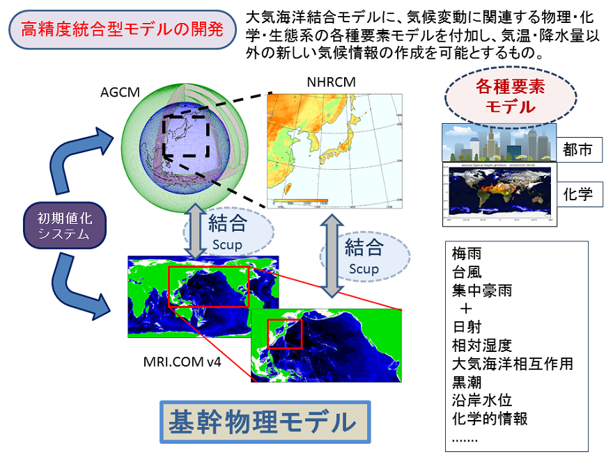
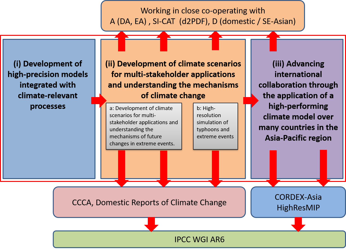
このように、気候変動の影響への適応策を自治体単位で打ち出すためには、第1次情報として様々な気象要素に関する高精度で高解像度の将来予測情報が必要になる。本研究課題では、このような今後の多様な社会的要請に対応していくために3つの領域課題により研究を進めた。領域課題(ⅰ)「高精度統合型モデルの開発」では、創生プログラムまでは大気モデルを用いた気候計算が中心であったが、気象・気候の様々な事象に対する海洋の影響を考慮し、大気海洋相互作用を評価できる高解像度大気・海洋結合系ベースの気候モデルへ移行する。また、新たなモデルコンポーネントを導入し物理変数の精度を向上させ、環境評価に必要な化学的気候情報が作成可能となるモデルの統合化に取り組む。また、本業務においては、将来予測実験のみならず、過去の温暖化を気候学的に検証するために、過去の大気海洋観測データと、創生プログラムで開発したアンサンブルデータ同化システムを発展させて、150年気候再解析を試みる。
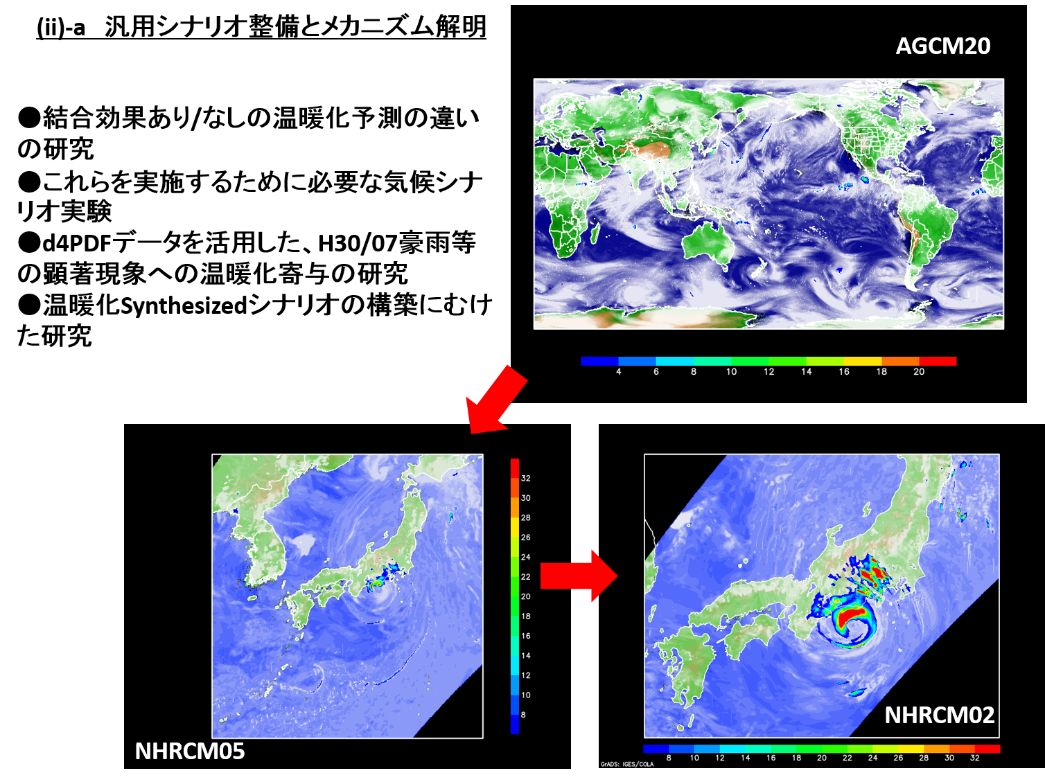
領域課題(ⅱ)「汎用シナリオ整備とメカニズム解明」では、水資源・農業・健康など、多岐にわたる影響評価やリスク管理での利用に耐えうる温暖化気候データセットを「汎用シナリオ」として整備するとともに、それらデータを用いた顕著現象や極端現象の将来変化メカニズムの研究を高解像度の全球・領域大気モデルの特徴を生かして実施し、より信頼度が高く、メカニズム研究にも利用可能な気候シナリオデータセットの構築を目指す。また台風の将来変化に特化した領域大気海洋結合モデル及び雲解像モデルによる実験を実施し、メカニズムに着目しながら顕著現象の将来変化の不確実性評価に取り組む。
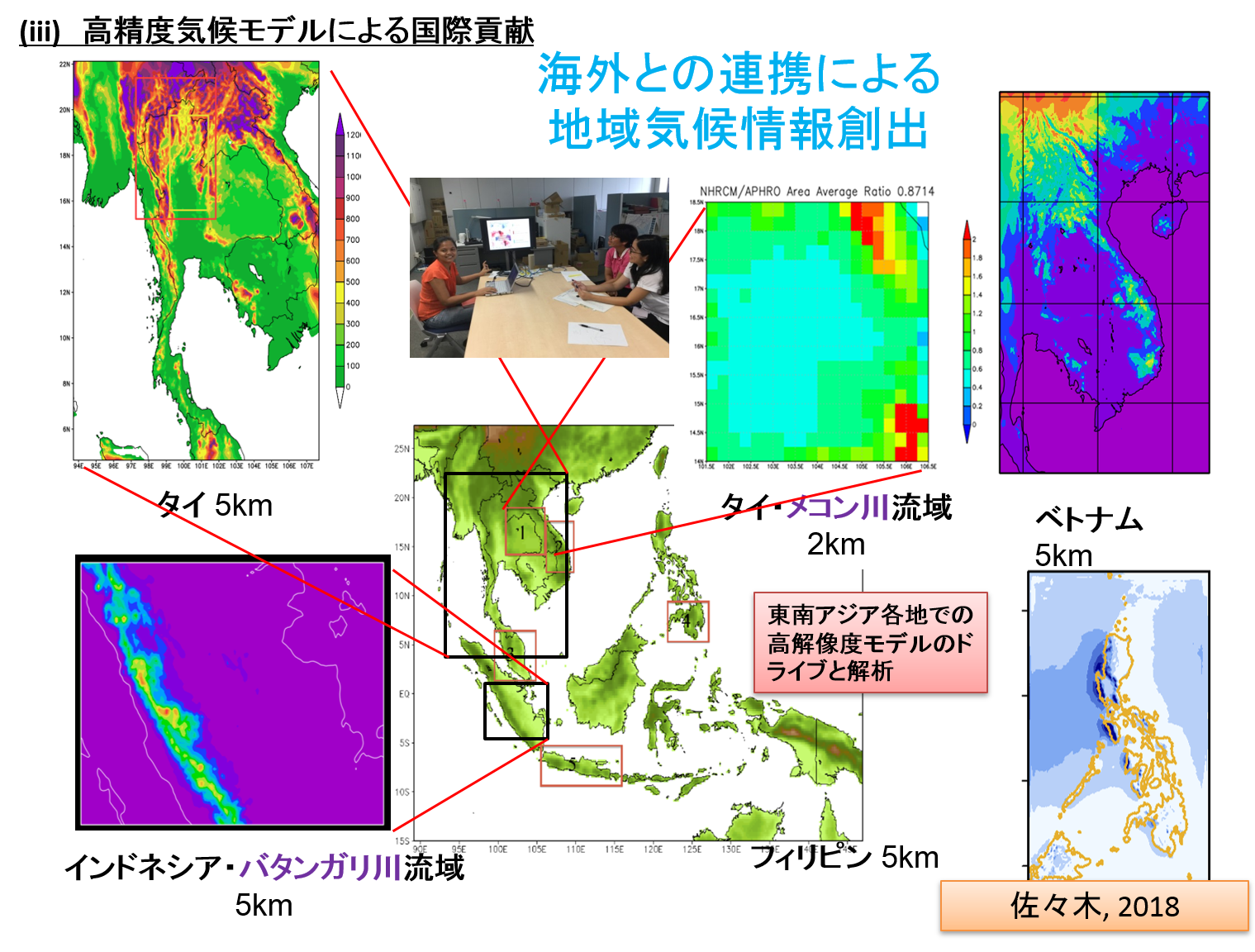
領域課題(ⅲ)「高精度気候モデル及び評価結果のアジア・太平洋諸国への展開と国際貢献」では、東南アジア・中米などを対象として、気象研究所が開発したダウンスケーリングモデルを国際的にも普及させる取り組みを行う。本領域課題においては領域テーマC、D連携の枠組みを利用して現地の影響評価研究に活用してもらう仕組みの実現も試みる。
本課題の社会へのアウトリーチは、国内的には、当プログラムの領域テーマD「統合的ハザード予測」、気候変動適応技術社会実装プログラム(SI-CAT)等との連携、また気象庁「地球温暖化予測情報」、環境省「気候変動適応情報プラットフォーム」等を活用し社会への情報提供を行う。また国際的には、IPCCへの貢献を行うとともに、結合モデル相互比較計画(CMIP)や統合的地域ダウンスケーリング研究計画(CORDEX)-アジアなどの国際共同研究へ積極的に参加する。これにより、本研究の計算・解析結果が各国の「地球温暖化予測情報」に反映されるとともに、東南アジア諸国・中米等との連携を通じた現地気候研究者の人材養成を行うことにより、我が国発の気候モデルがアジア地域における事実上のデファクト・スタンダードとなることを目指す。
以上の目的のため、本事業では以下の研究課題を実施する。
領域課題(i)「高精度統合型モデルの開発」領域課題(ii)「汎用シナリオ整備とメカニズム解明」
サブ課題a「汎用シナリオ整備と顕著現象変化メカニズム解明」
サブ課題b「台風等極端事象の高解像度ダウンスケーリングシミュレーション」
領域課題(iii)「高精度気候モデル及び評価結果のアジア・太平洋諸国への展開と国際貢献」

平成30年度の成果目標及び業務方法
領域課題(i)「高精度統合型モデルの開発」
(目標)
温暖化研究及び影響評価・適応研究に有用な中長期気候予測プロダクトの生成が可能となる統合型モデルについて、その基幹部となる新しい大気モデルの開発を進め、他のモデルコンポーネントについては既存のモデルをベースに開発する。
(業務の方法)
新しく開発する大気モデルに、気候モデルとしての性能を高めるために必要な各種物理スキームを導入する。大気以外の要素については、既存の海洋モデルや化学物質輸送モデル等を地球シミュレータ上で動作するようにし、既に動作している領域モデルを含めて統合型モデルとする。このモデルを用いて、従来のタイムスライス実験を行い、台風や梅雨などの顕著現象を再現するメカニズムに関わる実験を行う。領域モデルについては海洋モデルと結合させた実験を行い、海洋の詳細情報を与えたときの天気現象の再現性を調査する。また、150年気候再解析のためのアンサンブルカルマンフィルタに基づくデータ同化システムを地球シミュレータ上で動作できるようにし、気候再解析の予備実験を行う。

領域課題(ii)「汎用シナリオ整備とメカニズム解明」
(目標) (業務の方法) (目標) (業務の方法) (目標) (業務の方法) 業務の遂行に当たっては、研究連絡会を開き各課題間の連携を確認するとともに、外部有識者等からなる研究運営委員会で得られた全体の研究課題に対する意見や示唆により研究の方向性を確認・修正する。統合領域テーマD との連携を図るため、C/D 連携研究会を領域テーマD と共催し、また国内外の関連会合に参加して情報交換を行う。研究のアウトリーチとしては、一般向けの講演会等機会を得て研究成果を公開するとともに、成果の進捗状況の把握及び情報発信に努めることで業務の効率的・効果的な運用を図る。さらに、より成果を社会実装に近づけるために、気候変動の将来予測等に関する種々の科学的知見をアピールする場や取りまとめる場(国際会議や国内検討会等)など、本業務での研究活動を打ち込む機会を適宜活用しながら、必要に応じて成果集も作成・活用してアウトリーチ活動に取り組む。本課題成果の温暖化研究への有効活用を目指し、国内外の各種温暖化適応研究プロジェクトとの連携を図る。今年度計算されるデータの蓄積と解析のためにストレージシステムを増強する。
これまで高解像度大気モデルにより実施してきたタイムスライス実験を、今後は、大気と海洋を結合した高解像度気候モデルにより実験できるシステムを開発することが本サブテーマの主たる課題である。また、観測データを同化するスキームを取り込んで、結合モデルに過去と将来の気候状態を与えて気候シミュレーションができるように既存の実験システムを拡張する。使用するモデルについても更新する計画で、高解像度実験に耐えうる新しい大気コンポーネントの開発を本課題で実施する。 サブ課題(a)「汎用シナリオ整備と顕著現象変化メカニズム解明」 大気全球-領域気候温暖化予測システムを用いて、日本付近の降水の温暖化予測を行ってきたが、梅雨/夏季降水量などの平均降水量については、モデル構成や実験設定の違いにより予測結果がばらついており、不確実性が大きいことが示唆されている。60km格子全球大気モデル(MRI-AGCM)及びCMIP5大気海洋結合モデル(CMIP5)によるアンサンブル実験結果に基づき、日本付近の夏季降水量の将来変化とその不確実性について系統的に調べた。 サブ課題(b)「台風等極端事象の高解像度ダウンスケーリングシミュレーション」 台風はしばしば東アジア地域に暴風や豪雨により災害をひきおこす。本研究はそのような極端事象をもたらす台風を対象に高解像度シミュレーションを行い、最大強度到達メカニズムを明らかにするとともに、擬似温暖化実験や力学的ダウンスケーリング実験、さらに環境場に対する感度実験により、気候変動に伴い将来台風が強度や到達緯度についてどのように変わるのかを明らかにすることを目的とする。本年度は、特に中緯度顕著台風を対象に、領域大気海洋結合モデルCReSS-NHOESと雲解像モデルCReSSを用いた台風の再現実験や擬似温暖化実験、及び全球モデル実験でみられた台風のダウンスケーリングシミュレーションを実施した。 当課題では脆弱地域における温暖化予測を支援するために、東南アジア各国から研究者を招聘し、詳細な気候シナリオの作成を行っている。本年度は、統合の予算でマレーシアとフィリピンからそれぞれ1名ずつ、またその他の予算でベトナムから1名の研究者を招聘した。招聘期間は、それぞれ約2か月で、各国において気象研究所非静力学地域気候モデル(NHRCM)を使って、20km格子気象研究所全球大気気候モデル(AGCM20)の計算結果からの力学的ダウンスケーリングを行った。計算結果については、各国に持ち帰り詳しい解析がなされるとともに、統合Dに渡され、影響評価研究に利用されている。 Japan Meteorological Business Support Center: Izuru Takayabu Main mission of Theme C is to bridge the climate change data and their users, especially, impact
study researchers of climate change. In Japan, to establish climate adaptation plan is also a pressing issue. Cabinet has decided "National
Plan for Adaptation to the Impacts of Climate Change" in November 2015. By promoting adaptation
measures to climate change impacts, we build a secure, safe and sustainable society that is able to
minimize and avoid damage for lives of citizens, properties, economies, and natural environment,
and is resilient against damage (Vision of Society). Following to the decision, Ministry of the
Environment (MOE) has started the action of A-PLAT (Climate Change Adaptation Platform) in
August 2016, where many local scale climate change information is collected. Also, MOE, Ministry
of Agriculture, Forestry and Fisheries (MAFF), and Ministry of Land, Infrastructure, Transport and
Tourism (MLIT) have started "Regional Adaptation Consortium" in 2017. The mission of the
consortium is to promote local government to make a plan for climate change adaptation. Finally, in
December 2018, "Climate Change Adaptation act" has been enacted, and prefectures and
municipalities shall, either independently or in coordination with each other, endeavor to formulate a
local climate change adaptation plan in order to promote policies regarding Climate Change
Adaptation, in accordance with the natural, economic and social circumstances of their local area.
MOE established Center for Climate Change Adaptation (CCCA) in National Institute for
Environmental Studies, Japan (NIES), and it starts to promote adaptation and research related to
climate change adaptation in the local government. To promote these activities, high resolution, high
accuracy climate change projection data is needed. To enable the establishment of a climate change adaptation plan in the unit of local Government, we
need to project more accurate and less uncertain information of climate change in local scale. For this
purpose, we have designed our project as shown in Fig. 2. We have three sub-programs, and many coworking
or relation have been established with many domestic and international climate change
projects or activities. Japan Meteorological Business Support Center: Masayoshi Ishii For further improvement of future-projection products used for climate change adaptation and
mitigation, we are developing global and regional coupled models of high resolution, which is a
revision of the current global climate model of the Meteorological Research Institute (MRI) of the
Japan Meteorological Agency. So far, we conducted time-slice experiments with high-resolution
atmospheric models for future changes in extreme weather and climate events such as typhoon and
heavy precipitation. The versions of the same model have been used under consecutive domestic
global-warming research programs called KYOSEI, KAKUSHIN, and SOUSEI. The model
performances are still the best among atmospheric models used for global warming studies worldwide.
However, in order to keep the model bias minimum, the models use specified sea surface
temperatures, ignoring air-sea coupling processes. That is why we introduce coupled models for
conducting future projections with time-slice experiments. Such coupled experiments provide us more
physically consistent products than ever and these should be informative in relation to understand
future climate changes in extreme events as well as mean states. We also plan to examine possibility of
atmospheric chemistry products by introducing chemistry models including complicated chemical
processes and transportation. These physical and chemical products will hopefully respond to various
social demands. a: Development of climate scenarios for multi-stakeholder applications and understanding the mechanisms of future changes in extreme events Japan Meteorological Business Support Center: Toshiyuki Nakaegawa Mechanism of future changes in extreme climate phenomena and uncertainties were investigated
based on numerical experiments using MRI-atmospheric general circulation model (MRI-AGCM) and
dynamical downscaling with Non-Hydrostatic Regional Climate Model (NHRCM). b: High-resolution simulation of typhoons and extreme events Nagoya University: Kazuhisa Tsuboki The purpose of the present study is to estimate future changes of maximum intensity, associated
rainfall amount and northward shift of maximum intensity position of very intense typhoons with the
climate change by high resolution simulations, pseudo-global warming experiments, and sensitivity
experiments. This study uses a cloud-resolving model, Cloud Resolving Storm Simulator (CReSS) and
a regional coupled atmosphere-ocean model, Non-hydrostatic Ocean model for the Earth Simulator
(CReSS-NHOES). Japan Meteorological Business Support Center: Hidetaka Sasaki 1) Climate change projection in vulnerable areas Three researchers were invited to MRI in order to conduct collaborative researches on climate
change projection around their homelands in FY2018. First of all, the non-hydrostatic regional climate
model (NHRCM) is used to simulate present and future climate in Malaysia with a grid spacing of 5
km. Generally, the spatial distribution and annual cycles of both variables are well reproduced by the
model with slightly cold (for temperature) and wet (for rainfall) biases particularly over the
mountainous area of East Malaysia. Second, NHRCM is used to simulate the rainfall and temperature
over Vietnam at 5 km horizontal resolution for present and far future climate driven by MRIAGCM20
data. The simulations capture the spatial distribution of rainfall quite well as compared with
Vietnam Gridded Precipitation (VnGP) Dataset. Third, NHRCM is used to dynamically downscale the
MRI-AGCM3.2 model output for the Philippines at 5 km resolution, which is then further downscaled
for Mindanao at 2 km resolution. Present and far future climate with RCP8.5 scenarios are simulated.
Initial analysis shows that NHRCM is able to capture the spatial distribution of boreal summer rainfall
over Mindanao for 1981-2000, which is overestimated in comparison with APHRODITE but
underestimated in comparison with Climate Hazards Group InfraRed Precipitation with Station data
(CHIRPS). The interannual boreal summer mean rainfall averaged over Mindanao also shows this
disagreement in the bias in comparison with the observation data used. These results highlight the
need for understanding the inherent biases of the observation dataset. The present climate simulation
was conducted by using NHRCM05 around Batang Hari River basin in Indonesia in the previous
financial year. After confirming the reproducibility of the data, future climate projection was carried
out there and calculated results were provided to Theme D in this fiscal year. 2) International comparison of climate change projection The simulation of the present climate was completed by using 20 km grid spacing AGCM in order
to participate in international project to compare the results of high-resolution global models
(HighResMIP). Downscaling experiments from ERA-Interim and AGCM were completed by using 20
km grid spacing NHRCM over East Asia region in order to participate in Coordinated Regional
Climate Downscaling Experiment-East Asia (CORDEX-EA).
顕著現象将来変化の結合効果を含めた要因分析と気候シナリオ実験を行う。
顕著現象の将来変化メカニズム解明と不確実性定量化のために、高解像度の大気大循環モデル(AGCM)実験と、大気と海洋との結合効果を取り入れたAGCM温暖化実験、それぞれについて解析を行い、結合効果の将来予測への影響を明らかにする。また、領域気候モデルによる現在・将来気候実験の結果を解析し、極端な現象の将来変化のメカニズムについての解析を行う。地球温暖化対策に資するアンサンブル気候予測データベース(d4PDF)の延長実験を継続する。豪雨等の顕著現象に関するイベントアトリビューション研究を行い、温暖化の寄与を定量化し、要因分析を行う。AGCMと気象研究所地域気候モデル(NHRCM)による温暖化予測システムにより整備してきた温暖化予測データセットの、CMIP5マルチモデルアンサンブル内での位置づけについて解析を引き続き行い、表現されている不確実性の幅を定量化する。AGCM-NHRCM温暖化予測システムを用いて、力学的ダウンスケーリング気候実験を継続して実施する。顕著現象の変化遷移を調査するために、100年以上連続実験を引き続き行う。第1年度に実施した実験結果を評価し、順次、領域テーマDへ提供する。
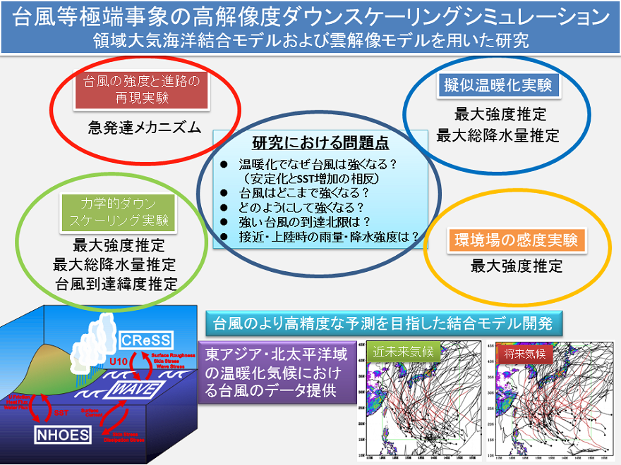
領域大気海洋結合モデル及び雲解像モデルを用いた台風のシミュレーション実験により、台風の強度と台風に伴う中緯度域の雨の将来変化推定を実施する。
本研究では雲解像モデル及び領域大気海洋結合モデルを用いる。観測された顕著な台風についての再現実験を行い、中緯度における雨量の再現性を検証するとともに、豪雨のプロセスとメカニズムを調べ、温暖化気候の環境場を与える擬似温暖化実験などにより雨の将来変化予測を実施する。また、温暖化に伴う台風の強度及び中緯度の降水強度・降水量の将来変化を推定するために、全球モデルの台風の力学的ダウンスケーリング実験を実施する。
海外を対象として高分解能気候モデルによる温暖化予測実験を行う。
CORDEX-東南アジアの参加国から研究者を招聘し、地域気候モデルNHRCMの使い方の指導を行う。CORDEX-東南アジアで指摘されている脆弱地域において、高分解能のNHRCMによる現在気候再現実験及び将来予測実験を行い、その結果を解析する。NHRCMによって計算された東南アジアにおける現在気候再現実験結果の影響評価研究への適用方法についての検討を領域テーマDと連携をとりながら行う。高解像度気候モデル相互比較実験(HighResMIP)に参加するため高解像度のAGCMを用いた現在気候再現実験を続ける。CORDEX-東アジアに参加するためにNHRCMで計算された現在気候の再現性を評価する。
領域課題(i)「高精度統合型モデルの開発」
これまで力学的ダウンスケーリングに使用してきた非静力学領域気候モデルNHRCMは、現時点までに国内外の多数のユーザの支持を得て、広く活用されてきている。ただし、NHRCMのプロダクトのうち、気温と降水量以外の要素については、その再現精度に問題があり、影響評価研究の利用に耐えうるものではないことから、モデルの改良が必要であることが分かっている。諸般の事情により、NHRCMを改良して課題解決する選択をせず、最新の気象庁現業モデルをベースにした新しい領域気候モデルの開発に移行することを決めた。気温と降水量以外の要素についての当面の対応としては、バイアス補正を施して利用することで対応していきたい。
大気の温暖化予測プロダクトに加えて、海洋の水温、水位、潮流などのプロダクトの要請も多方面からいただいているところである。地球温暖化においては、海洋の変化も社会にとっては深刻である。一方で、日本近海では、黒潮、親潮に加えて日本海のような閉鎖的海盆が存在するなど複雑な海洋構造をとっている。現状の低解像度な気候モデルでは、これらの海洋変動を適切に表現できてはいない。将来変化についても同様の事情があり、従来の大気モデルによるタイムスライス実験では、日本近海において適切ではない海面水温を与えて、大気の将来変化の計算を行っているという可能性がある。今後のタイムスライス実験システムでは、これらの問題を解決すべく、大気と海洋を結合したシステムの開発の中で、日本近海の海洋構造を適切に再現し、より確からしい将来予測プロダクト生成の可能性を探っていくことにする。
気象研究所の大気海洋結合モデルの大気モデルや化学輸送モデルに関わる、本年度に実施して得られた個別の研究成果について以下報告する。
非静力学オプションを搭載して、10km以下の解像度でも軽快に動作する新しい大気モデルの開発は順調に進み、既に開発が終了している海洋モデルと結合するところまでを本年度までに完了した。大気海洋結合モデルをベースとした新しいタイムスライス実験システムの開発では、既存結合モデルの地球シミュレータへの移行や、海洋をデータ同化するスキームの組込みを行った。さらに、予備実験を行い、領域モデルを用いたダウンスケーリングシステムを調整する段階まで進めた。
観測データに基づく客観的情報を温暖化研究に活用するために、いくつかの試みを行っている。海面水温や海洋表層水温などの海洋観測の長期データは、モデル実験に不可欠なものであり、国際協力のもとで、常時、それらの品質の向上を図っている。また、気候モデルに地表面での気圧や海水温を同化する気候解析の試みにも取り組んでいる。本年度は、気候解析において、台風の軌跡を頼りに台風を維持する同化スキームの開発と調整を行った。
将来の夏季降水量の予測では、熱帯域海面水温の温暖化トレンドのパターンに大きく依存することが分かり、今後のタイムスライス実験の温暖化摂動の与え方を考える上で重要な示唆を得た。新システムでは大気海洋結合過程を導入するが、既に実施している結合モデルによる実験結
果を解析して、注目度の高い東アジアを含む北西太平洋域の降水の再現に、結合プロセスが少なからず影響を与えることが分かった。領域大気海洋結合モデルの開発では、初年度に実施した高解像度海面水温を用いたシミュレーション実験を解析し、高解像度の海面水温情報を用いることで、日本の南岸域を中心にして、モデル気候値のバイアスが減少することを確認した。さらに、高解像度の領域大気モデルと海洋モデルを結合しながら時間積分できる機能を付加して、結合実験に着手した。
領域課題(ii)「汎用シナリオ整備とメカニズム解明」
その結果、夏季平均降水量と月平均降水量はいずれも、東アジアのスケールでは増加傾向だが日本列島のスケールでは不確実性が大きいことが示された。また、6月に梅雨降水帯が強化してやや南下する傾向にあり、数値実験から、海面水温(SST)一様上昇に伴う水蒸気増加と亜熱帯
ジェット南下がその主要因であることが分かった。
大気と海洋との結合効果を取り入れたAGCM温暖化実験(準結合実験)の実施により、大気海洋結合効果が北西太平洋域の夏季降水及び極端降水に与える影響が議論できるようになった。平均降水量に対しては全球大気モデル部分の解像度によって傾向が変わるものの、有意性が高い全球20km解像度は本州南岸付近の増雨予測域をAGCM実験より南にシフトさせると共に、フィリピン付近の減雨予測をAGCMより弱くするように働くことを示唆した。
地球温暖化に伴う極端な降水の変化については、地域平均で見た場合に頻度の小さい、すなわち強い降水量の事象ほど、増加が大きくなることが予測されており、Clausius-Clapeyron式の2倍程度の極端豪雨が降りうるという説明があるが、今回は鉛直速度変化率がスケールによって異なる原因を調べた。
MRI-AGCM3.2を用いたd4PDFのデータセット群と創生・統合で行ってきた実験を統合的に用いて、台風の将来変化傾向について調べた。その結果、1)全ての台風の発生数は温暖化シナリオ(熱帯海面水温変化)で概ねスケーリング可能、2)20kmモデルはRCP2.6で非常に強い台風の数が増加し、RCP8.5では減少、3)台風の存在頻度の空間分布は弱い温暖化(2℃昇温)と強い温暖化(4℃昇温)時とほぼ同様のパターン、4)強い台風の存在頻度は弱い温暖化でも全体的な減少と、日本の南、ハワイ、メキシコの西を含む広い領域での増加となった。
MRI-AGCMと気象研究所地域気候モデル(NHRCM)による温暖化予測システムにより整備してきた温暖化予測データセットの、CMIP5マルチモデルアンサンブル内での位置づけについて解析を引き続き行った。60km格子MRI-AGCMの現在気候降水量再現性は、世界26地域のほとんどでトップクラスの再現性を示した。また、60km格子MRI-AGCMの積雲スキーム・将来SST変化アンサンブル実験で表現される将来降水量不確実性の幅を、CMIP5マルチモデルアンサンブルによる不確実性の幅と定量的に比較し、相対的に低緯度地域で不確実性の幅が大きく、中・高緯度地域では小さいことが分かった。この特徴はIPCC AR5 WGI で示されたCMIP5に見られる特徴と一致する。
日本の極端な短時間降水量の将来変化に対する力学及び熱力学過程の影響について、2km格子の雲解像地域気候モデル(NHRCM02)によるRCP8.5の基での今世紀末における気候予測実験の結果を解析した。極端降水の指標となる鉛直積算した水蒸気フラックス収束の変化量を力学過程及び熱力学過程の寄与に分解した結果、沖縄東方海上では力学過程の寄与が熱力学過程よりも大きく、紀伊半島沖ではその逆で、熱力学過程が大きいことが示唆された。
d4PDFの延長実験を継続した。このd4PDFの領域モデルと全球モデルの結果を合わせて解析することで、2018年7月に被害をもたらした豪雨と猛暑のイベント・アトリビューション(EA)を試みた。6月29日~7月8日の期間平均で見ると西日本を境に東西の気圧ダイポール構造が見られ、南から水蒸気が流れ込みやすい場になっていて、このような構造は全球モデルの過去再現実験の100メンバー平均値でも見られ、総観スケールの気候場でもこのような構造が卓越しやすく、メソスケールの現象による要因を底上げしていたと考えられる。また、過去再現実験と非温暖化実験の比較から、瀬戸内地域では、力学的効果を代表する指標の変化は小さく、熱力学的な効果が水蒸気増加を通して、豪雨をもたらしたと考えられる。
また、九州地区における100mmを超える日降水量の変化を過去再現実験と非温暖化実験で比較したところ、九州西部では増加が認められた一方、東部では認められなかった。九州東部の大雨は台風にもたらされる事が多い。一方、西部は日本の南海上の高気圧性循環の強化と日本海のトラフに関連していることが多い。九州西部の可降水量増加は、C-C式から推測される増加率と一致している一方、台風の接近数が過去再現実験では非温暖化実験と比較して10%少ないことが九州東部の大雨日数増加に結びつかないと考えられる。
これまで、極端降雨事例に対するEA研究は難しいとされてきたが、d4PDFの領域モデルの結果を利用することで、日本列島の地域的な大雨事例に対するEA が可能となったことは目覚ましい成果である。これらの延長実験並びに、解析は本プログラムのテーマA と連携して実施したものである。
大気全球-領域気候温暖化予測システムを用いて、全球20km、領域5km、2kmの力学的ダウンスケーリング気候実験を継続して実施した。今年度は、RCP2.6におけるSSTアンサンブル実験2メンバーを実施し、SSTアンサンブル最後の4メンバー目の実験を開始した。また、顕著現象の変化遷移を調査するために、CMIP6HighResMIPの実験設定に準拠した100年以上連続実験を引き続き行った。第1年度に実施した実験結果を評価し、順次、領域テーマD へ提供した。
まず、中緯度顕著台風の代表例として2017年台風シーズン最強のスーパータイフーン・台風Lan(2017)を対象に再現実験を実施し、モデルの再現性を検証した上で、最大強度にいたるプロセスとメカニズムを調査した。Lanの特性の再現に成功した高解像度モデルの結果から、環境場の鉛直シア風下で励起された活発な対流による最大風速半径内側での潜熱解放と鉛直シア風上で励起された沈降場が目の中に貫入することによる断熱昇温により、Lanの中心気圧が低下し、日本のすぐ南海上まで強度を維持したことが明らかになった。台風の通過に伴う海面水温低下の効果を考慮したモデルでのみ、これらLanの強度や降水分布の時間変化の再現に成功した。これにより、海面水温低下の影響を受けにくいとされる移動速度の速い台風であっても、台風の強度をより精度よく予測するには、台風中心の詳細な対流構造や物理プロセスを精緻に表現し、かつ海面水温低下を再現する精巧な数値モデルが必要であることが示された。
次に、全球モデルの台風の力学的ダウンスケーリング実験として、d4PDFからのダウンスケーリング実験に着手した。まず、d4PDFから日本に大きな影響を与える台風として、日本の東海上を北上し北海道に上陸する台風を抽出した。過去実験及び4度上昇実験でそれぞれ98例及び125例と100例前後が抽出された。これら該当台風の経路データを調査したところ、将来、温暖化が進んだ場合、最大強度や最大強度到達緯度が北上するのみならず、日本付近における北上速度に統計的に有意な遅延傾向が見出された。温暖化に伴う台風の強度及び中緯度の降水強度・降水量
の将来変化を定量的に評価するため、これらすべてを対象に高解像度かつ台風の通過に伴う海面水温低下の効果を考慮したCReSSによるダウンスケール実験を2 年計画で実施する。初年度にあたる平成30年度は、過去実験・4度上昇実験で各50例ずつ実施する予定であったが、平成31年
3月までに各60例ずつの実験を完了する見込みとやや前倒しで進捗している。終了したダウンスケーリング実験の結果を用いて、1台風あたりの総雨量、最大1 時間降水量、最大10m風速、期間内最低海面更正気圧等の将来変化を予備的に見積もったところ、特に関東以北の太平洋側で総
雨量が増加する傾向がみられた。顕著な大雨現象を伴った台風についての擬似温暖化実験としては、2016年8月後半に関東以北の太平洋側を中心に大雨をもたらした4つの台風事例を選び、8月14日~31日までの期間についてCReSS-NHOESによる擬似温暖化実験を実施した。水平分解能
を0.04度としたもの以外にも0.02度と高解像度化した実験を実施した他、海水温差分の与え方を変えた実験等、感度実験のメンバーを積み増した。これら擬似温暖化実験の結果とd4PDF にみられる、台風を雲解像モデルCReSS でダウンスケーリングした実験の結果を合わせることで、台風
やそれに伴う雨について、より詳細かつ定量的な議論が可能となることが期待される。
領域課題(ⅲ)「高精度気候モデル及び評価結果のアジア・太平洋諸国への展開と国際貢献」
高解像度モデル相互比較プロジェクト(HighResMIP)と東アジアにおける地域気候モデル相互比較実験(CORDEX-EA)の2つの国際プロジェクトに参加するための実験を行った。HighResMIPでは、これまでに歴史実験を終了し、RCP8.5による将来予測実験の準備を開始した。また、CORDEX-EAでは、これまでに全球大気再解析データERA-Interimにネストした完全境界実験と気象研究所全球大気モデルAGCM60からダウンスケーリングした現在気候再現実験を終了し、アジアの水資源への温暖化評価のための日降水グリッドデータ(APHRODITE)と降水量分布の比較を行った。
Area Theme C: Integrated Climate Change Projection
Internationally, the process of writing the sixth assessment report (AR6) of IPCC has already
started. It is planned to be published in 2021. In AR6, handshaking among WGI (aims to assess the
physical science basis), WGII (assesses the vulnerability, socio-economic and natural systems), and
WGIII (focuses on climate change mitigation) is strongly recommended.
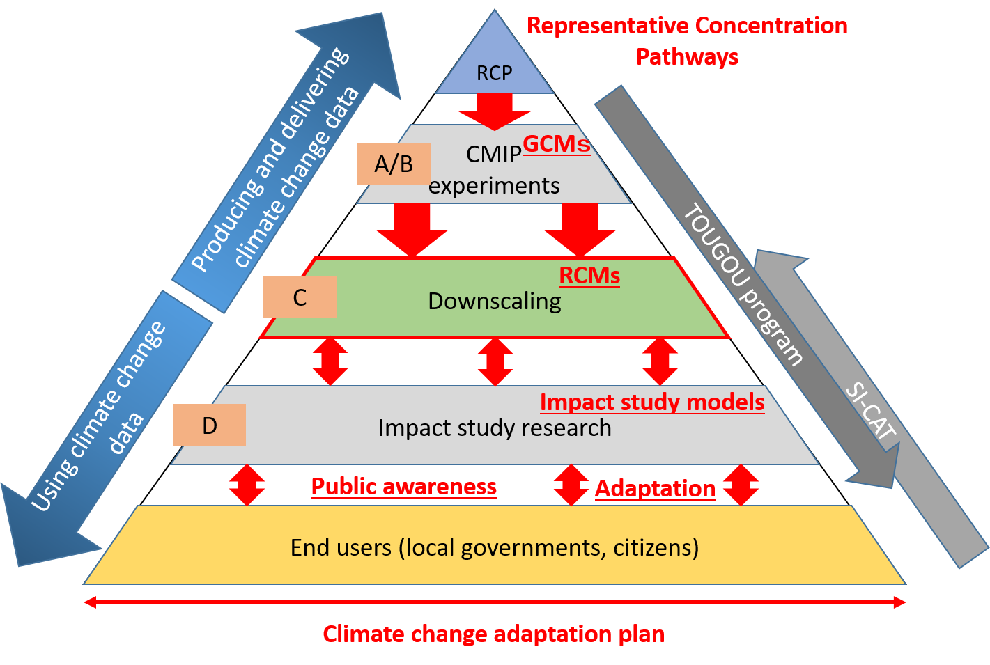
Figure 1 indicates the role of Theme C in the whole activity in translating/using the climate change
data. To bridge between the global climate change products and the impact studies, our mission, to
downscale the global climate model data into a local scale is an indispensable process.
Sub-theme (i): Development of high-precision models integrated with climate-relevant processes
Needless to say, understanding past climates for more than 100 years is as important as predicting
future climates in the next 100 years. At present, the past climates are limitedly known particularly
before the International Geophysical Year (1957-1958). Even in the past climate, big typhoons landed
on Japan islands, and the old Japan experienced severe disasters due to heavy rain and drought. It is
beneficial to modeling and climate predictions to understand how and why these events occurred as a
result of long-term climate fluctuations. Therefore, a study for 150-year climate reanalysis is
incorporated in this sub-theme. Here, we will develop a system of long-term data assimilation with
sparse observations.
Sub-theme (ii): Development of climate scenarios for multi-stakeholder applications and understanding the mechanisms of climate change
Our projections by MRI-AGCM with different experiment setups have shown large uncertainties in
future changes in the rainy season in Japan, Baiu. New ensemble experiments with MRI-AGCM in a
60 km grid spacing were conducted with future changes in sea surface temperatures (SSTs) projected
by atmosphere-ocean coupled models (AOGCMs) participating in the Coupled Model
Intercomparison Project phase 5 (CMIP5). It is revealed that future changes in precipitation amount in
Japan is highly uncertain, while those in a larger region such as East Asia is robust. Future changes in
precipitation are also investigated by the MRI-AGCM experiments partially including atmosphereocean
coupled processes, indicating that coupled process tends to shift the Baiu rain band more
southward than in the experiments without the processes under a future climate, as well as less
increase in convective activities in the Philippine Sea. In global scale, the MRI-AGCM experiments
suggest that future changes in extreme one-day precipitation is strongly relevant to the future changes
in the mid-tropospheric upward motion.
Performance of the future climate projection by MRI-AGCM is evaluated in comparison with the
CMIP5 multi-model ensemble (MME). The present-day precipitation in MRI-AGCM with a 60 km
grid is simulated very well in global 26 regions compared with the CMIP5 MME. The uncertainties in
the ensemble with different convection schemes and different future change patterns in SST in the
MRI-AGCM experiments are relatively large in low latitudes while they are small in mid- and high-latitudes.
Performance of the future projection by NHRCM is also evaluated. It is revealed that a dominant
process of future changes in extreme hourly precipitation in the seas around Japan is different from
each region: dynamical process for Okinawa region and thermodynamical process for Kii-offshore
region. The event attribution is applied to the heavy rainfall event and heat waves observed in July
2018 for evaluating the influence of the global warming on them, using regional d4PDF, which was
donwscaled from global d4PDF. An east-west surface pressure dipole is simulated during the heavy
rainfall event in global d4PDF and enhances meso-scale phenomena. Regional d4PDF enables to
evaluate the influence of global warming on recent local heavy precipitation events in western Japan.
The recent change in the heavy precipitation events appears in the western Kyushu, but it does not so
in the eastern Kyushu. The changes in the western Kyushu region are explained by the
thermodynamical effect estimated with the Clausius-Clapeyron relation under the current global
warming. These researches with d4PDF are performed in cooperation with Theme A and Theme C.
Future climate projections with dynamical downscaling from high-resolution MRI-AGCM with a 20
km grid are conducted continuously to increase ensemble members. NHRCMs with a 5-km grid and a
2-km grid are used for this regional projection under RCP2.6 scenario. These future projection data of
Theme C are continuously provided to Theme D researchers.
Using CReSS, we performed a simulation experiment of Supertyphoon Lan (2017), which was the
most intense typhoon in 2017. The simulation result was compared with observation and was found
that it agreed well with the observation. The process of intensification of Typhoon Lan was studied
using the simulation result. We found that latent heating due to intense convection within the radius of
maximum wind speed and forced descending motion caused the central pressure decrease of the
typhoon. Since the Sea surface temparature (SST) decrease due to typhoon motion was considered in
the simulation, the intensity of Typhoon Lan was correctly simulated. This indicates that the ocean
process is important for the accurate simulation of typhoon even though the movement speed of
typhoon is large.
Dynamic downscaling simulations (DDSs) of typhoons in a GCM simulation were also performed
using d4PDF data for initial and boundary conditions. Northward-moving typhoons to the east of
Japan in the d4PDF data were selected for the DDSs, because they have large impact on the midlatitude
countries including Japan. The numbers of the selected typhoons are 98 and 125 for the
present climate and 4 K increased climate, respectively. They showed that points of the maximum
intensity shift northward and the northward-moving speed of typhoon decreased in the 4 K increased
climate. According to DDSs of the northward-moving typhoons of d4PDF, rainfall amount of typhoon
increases over the Pacific to the north of Kanto. These experiments were combined with the pseudo-global
warming experiments of the four typhoons moved northward to the east of Japan in 2016 to
study future change of rainfall amount and intensity of typhoons with the global warming.
Sub-theme (iii): Advancing international collaboration through the application of a high-performing climate model over many countries in the Asia-Pacific region